
Ayrshire prepares for the coldest spell of weather since 2010 as "Beast from the East" arrives!
- Ayrshire Daily News
- Feb 23, 2018
- 3 min read

Next weeks weather is set to be extremely cold across Ayrshire next week with daytime temperatures no higher than 3c while nighttime temperatures will sit around -9c and lower as the week progresses.

A Level 3 severe weather warning has been issued across England however the same cold weather will arrive across Ayrshire from Sunday night.
Elderly people and Young kids are most at risk to colder weather and should now take time to prepare for this cold spell.
The weather expected next week could be colder than the winder spell of 2010 so stay tuned to ADN for regular updates!
11am Update - 23/02/18 - Extreme cold on the way!
If you still think it wont be cold, think again...
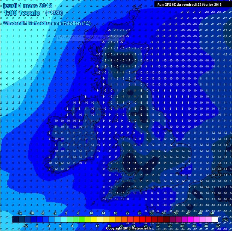
On Wednesday it will feel more like -10C in the wind, followed by a incredibly cold & frosty night with significant wind chill... Wherever snow lies, expect wind chill to feel as low as -20C.
Coming up just after 6:30pm
We talk about why some weather forecasters have never seen charts like this below and most likely set to beat the cold spell of 2010!

Look out for our updates on here just after 6:30pm!
18:30pm update - Why this cold spell could beat 2010
However this set up is slightly different with the Severe SSW warning this seen temperatures rise by almost 30c across the North poll sending the cold Air through Scandinavia and towards the UK. towns. Western Europe and towards the UK.
The last time a similar set up like this happened was back in December of 2010, If you remember this spell seen almost 98% of the country covred in some form of snow including Ayrshire coastal towns.
However this set up is slightly diferent with the Severe SSW warning this seen temperatures rise by almost 30c across the North poll sending the cold Air through scandanavia and towards the UK.
Over the past few days our weather forecasters have had a thrill watching the charts update showing more and more cold heading our way and on Twitter some weather forecasters have described why they have never seen charts like these and most likely wont again for at least 10-15 years if not more.
One thing for sure is that next week will be very, Very interesting and very, very cold with daytime temps struggling above freezing and nighttime temps around -11c especially the middle of next week.
Snow is also on the cards but we will talk more about this on Sunday!
Below is an update from our in-house weather forecaster Martin on some interesting things that could happen next week...

Martin Hendersons Analysis - ADN weather forecaster
It will not just be dry but very dry, What’s the difference? Very low dewpoints making the humidity very low, This can have some strange effects...
1. The very dry air evaporates the moisture quicker from your skin making it feel colder.
2. Static electricity builds up on heels of shoes and car tyres causing electric shocks when closing car doors.
Sunny, cold dusty dry all weekend, frosty nights but because of low humidity cars and pavements will have minimal ice deposits.
These two charts are a snow lovers dream if they verify next week. -22c over inland snowfields would be record breaking for March.
22:00PM Update - GFS Upgrades next weeks cold weather at the last minute!
An upgrade from 12z including Frequency of snow showers seems to be higher than on 12z run earlier. This is still over 4 days away so still time for some change however upgrades are more likely than downgrades...

Final details will be clearer by this time tomorrow Night but remember the cold Easterly winds start to arrive from tonight with plenty of sunny weather tomorrow and Sunday before turning bitterly cold from Monday!


